MapItFast- Field-based Mapping 7.7.2
Free Version
Publisher Description
MapItFast- Field-based Mapping - One tap to map points, lines, polygons and geophotos by GPS and drawing.
MapItFast turns your phone or tablet into a powerful mapping and record-keeping device, even in the backcountry while offline. One-tap mapping makes it easy to create points, lines, polygons, and geophotos to represent anything of interest in the field. Take it to the next level and use your own maps and custom electronic forms to record fieldwork that is seamlessly synchronized into your own cloud account.
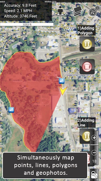
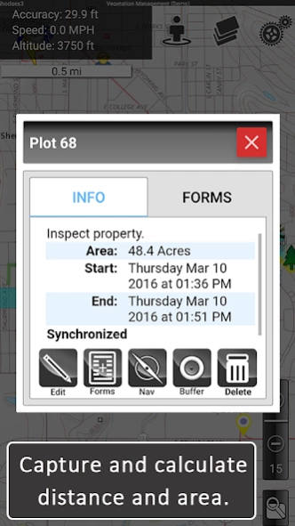
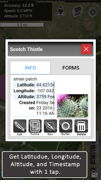
Mapping is super fast. You can tap the map object icons to create objects using GPS or long-press the icons to draw objects in by hand. Instantly view geophotos and display location information such as distance and area covered.
Pause and resume GPS tracking. Create multiple GPS lines or polygons at the same time. Drop points, take geophotos, and draw objects by hand without interrupting GPS tracking. Organize your mapping into projects to create your own custom atlas.
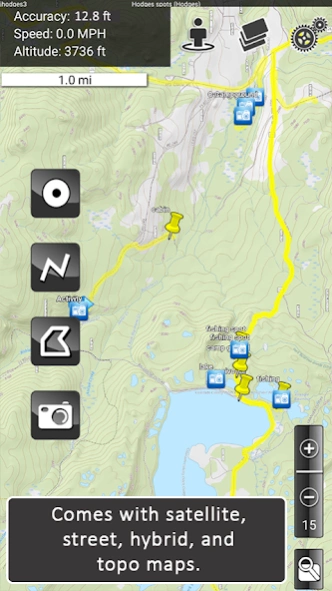
Arial, street, and topo basemaps come included to give you a clear reference for your mapping.
*****
MapItFast Professional is a paid version of the app designed for enterprise use with virtually no training or GIS knowledge required.
The paid version of MapItFast synchronizes projects and users on Android and Apple devices into your private cloud-based account. This enables you to make data collection more efficient as you collaborate on an unlimited number of projects and use your own custom designed forms to link data with map objects.
Paid version features include:
• Cloud-based account with maps and data synced across devices and the web
• Web-based portal to view projects, users and shared contributions in real time
• Ability to load and distribute your own custom, maps and symbology
• Integrated electronic forms to add attributes to map objects directly from the app
• Triggers that automatically change map symbols based on how a form is filled out
• Printable and emailable reports you customize with company logos, filled data, maps, photos and more
• GIS mapping tools such as object buffers, splits and donuts
• Searching, editing, sorting, copying, moving map objects among projects
• Importing shapefiles as editable map objects or as layer overlays
• Exporting to any GIS using formats including KMZ, Shapefile (SHP) and GPX
• Two-way, real-time synchronization between field devices and your online account
• User and group level project access and permissions
*****
Additional plugins allow you to automate mapping even further by connecting AgTerra's datalogging products to your mobile device.
• SprayLogger is specially designed to collect every detail for pesticide applications and generate automatic detailed reports.
• SnapMapper allows users to quickly creat points and lines in MapItFast with the flip of a switch from any mechanical device.
Field workers and natural resource professionals are currently using MapItFast for activities such as:
• Vegetation management & pesticide application reporting
• Mosquito trap inspection and vector control recording and reporting
• Inspections/ field surveys
• Crop scouting
• Wildfire and disaster response and prevention
• Rangeland management
• Water management
• Utility work
• Forestry monitoring/ timber cruising
Simplify mapping and easily manage data while improving field workforce efficiency for the entire organization. See more details in the product video. Learn more about all our products at www.agterra.com
About MapItFast- Field-based Mapping
MapItFast- Field-based Mapping is a free app for Android published in the Geography list of apps, part of Education.
The company that develops MapItFast- Field-based Mapping is AgTerra Technologies, Inc.. The latest version released by its developer is 7.7.2. This app was rated by 1 users of our site and has an average rating of 3.0.
To install MapItFast- Field-based Mapping on your Android device, just click the green Continue To App button above to start the installation process. The app is listed on our website since 2024-04-03 and was downloaded 46 times. We have already checked if the download link is safe, however for your own protection we recommend that you scan the downloaded app with your antivirus. Your antivirus may detect the MapItFast- Field-based Mapping as malware as malware if the download link to com.agterra.MapItFast is broken.
How to install MapItFast- Field-based Mapping on your Android device:
- Click on the Continue To App button on our website. This will redirect you to Google Play.
- Once the MapItFast- Field-based Mapping is shown in the Google Play listing of your Android device, you can start its download and installation. Tap on the Install button located below the search bar and to the right of the app icon.
- A pop-up window with the permissions required by MapItFast- Field-based Mapping will be shown. Click on Accept to continue the process.
- MapItFast- Field-based Mapping will be downloaded onto your device, displaying a progress. Once the download completes, the installation will start and you'll get a notification after the installation is finished.
